Canada Topo Maps
- 安卓
- 2025-09-24
- ⏳ 已提交(08-01 07:21)
- 81 ℃
- 0 评论
摘要
 越野和户外导航。多种地图:地形图、天线图、航海图等
Canada Maps
ATLOGIS Geoinformatics oHG
备案号:待更新
 安卓
安卓《Canada Maps》游戏 APP 是ATLOGIS Geoinformatics oHG开发的安卓系统应用软件,版本号:4.3.0 free,由丢塔游戏网整理,欢迎下载体验。
Easy to use outdoor navigation app with the best topographic maps of Canada. \\r
This app gives you similar mapping options as you might know from Garmin or Magellan GPS handhelds. \\r
*** Attention: Please use Toporama or Canada Base Map layer if you need most recent topo maps ! *** \\r
Main features for outdoor-navigation:\\r
• Bulk-download of map tiles for OFFLINE USAGE (NOT in this FREE version)\\r
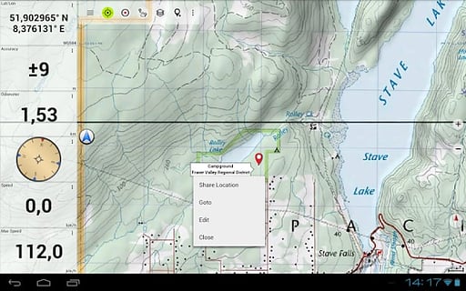
• Create and edit Waypoints\\r
• GoTo-Waypoint-Navigation\\r
• Create and edit Routes\\r
• Route-Navigation (NOT in this FREE version)\\r
• Track Recording (with speed, elevation and accuracy profile)\\r
• Tripmaster with fields for odometer, average speed, bearing, elevation, etc. \\r
• GPX-Import / Export, KML-Export\\r
• Search (placenames, POIs, streets)\\r
• Customizable datafields in Map View and Tripmaster (e.g. Speed, Distance, Compass, ...)\\r
• Share Waypoints, Tracks or Routes (via eMail, Facebook, ..)\\r
• Use Coordinates in UTM, WGS84 or MGRS\\r
• and many more ... \\r
Available map layers:\\r
• Topomaps Canada (CanMatrix, seamless coverage at scales 1:50.000 and 1:250.000)\\r
• Toporama Maps Canada in EN&FR (CanVec, NTDB, Atlas of Canada)\\r
• Canada Basemap (CanVec, NTDB, Atlas of Canada)\\r
• CanTopo (new Canada topos at 1:50.000, partial coverage of Can)\\r
• Google Maps (Satellite images, Road- and Terrain-Map)\\r
• Bing Maps (Satellite images, Road-Map)\\r
• Open Street Maps (OSM Mapnik and Cloudemade Cyclemap)\\r
• Hillshading overlay layer (NOT in this FREE version) \\r
Toporama Maps Canada: These are the most recent topographic maps of Canada. \\r
Topomaps Canada: These maps contain many small pathes and 4WD tracks that are missing in Toporama, Google, Bing and OSM maps. This layer is essential for real outdoor and offroad trips in Canada. Seamless mosaic of more than 13.000 collar clipped 1:50.000 maps. \\r
LIMITATIONS OF THE FREE VERSION:\\r
• Ads\\r
• No Bulkdownload\\r
• No Hillshading overlay\\r
• Max. 3 Waypoints\\r
• Max. 3 Tracks\\r
• No Routes\\r
• No import of waypoints and tracks\\r
• No Local City DB (Offline Search) \\r
Use this navigation app for outdoor activities like hiking, biking, camping, climbing, riding, skiing, canoeing or offroad 4WD tours.\\r
Preload FREE map data for areas without cell service. \\r
Canadian topographic maps are enhanced with Atlogis® hillshading and placenames.\\r
Credits for topographic map data: \\\"© Department of Natural Resources Canada. All rights reserved.\\\" \\r
Please send comments and feature requests to canadamaps@atlogis.com \\r
易于使用的户外导航应用与加拿大最好的地形图。 \\r
这个应用程序为您提供了类似的映射选项,你可能会从 Garmin 或麦哲伦 GPS 手持机知道。 \\r
***请注意:如果你需要最新的地形地图,请使用 Toporama 或加拿大底图层! *** \\r
户外导航产品主要特点:\\r
•地图图块的批量下载离线使用(而不是在这个免费版本)\\r
•创建和编辑路标\\r
•转到-航点导航\\r
•创建和编辑路线\\r
•路线导航(在此免费版)\\r
•轨录音(有速度,高度和准确度轮廓)\\r
•孙行者与里程表字段,平均速度,轴承,海拔等\\r
•GPX 导入/导出,KML 的出口\\r
•搜索(地名,兴趣点,街道)\\r
•在地图视图和孙行者定制的数据域(如速度,距离,指南针...)\\r
•共享航点,跟踪或路线(通过电子邮件,Facebook 的..)\\r
•使用坐标在 UTM,WGS84 或 MGRS\\r
• 还有很多 ... \\r
可用的地图图层:\\r
•Topomaps 加拿大(CanMatrix,无缝覆盖的尺度 1:50000 和 1:250.000)\\r
•Toporama 地图加拿大 EN 和 FR(CanVec,NTDB,加拿大的图集)\\r
•加拿大底图(CanVec,NTDB,加拿大的图集)\\r
•CanTopo(新加拿大 TOPOS 为 1:50000,能部分覆盖)\\r
•谷歌地图(卫星图象,和路 - 地形图)\\r
•Bing 地图(卫星图像,路线图)\\r
•开放街道地图(OSM Mapnik 的和 Cloudemade Cyclemap)\\r
•晕渲覆盖层(未在此免费版本) \\r
Toporama 地图加拿大:这是加拿大的最新地形图。 \\r
Topomaps 加拿大:这些地图包含许多小 pathes 和缺少在 Toporama,谷歌,Bing 和 OSM 地图四驱车轨道。这一层是在加拿大真正的户外越野和旅行必不可少的。超过 13.000 领的无缝拼接裁剪 1:50000 的地图。 \\r
免费版的限制:\\r
•广告\\r
•无 Bulkdownload\\r
•无晕渲覆盖\\r
•最大。 3 航点\\r
•最大。 3 曲目\\r
•无路线\\r
•航点和轨迹的无进口\\r
•没有地方城市 DB(离线搜索) \\r
使用适合户外活动,如远足,骑自行车,露营,攀岩,骑马,滑雪,划独木舟或越野四驱车之旅该导航应用。\\r
预紧为区域提供免费地图数据没有手机服务。 \\r
加拿大地形图是加强与山体阴影 Atlogis®和地名。\\r
地形图数据学分:“©系加拿大自然资源部保留所有权利。” \\r
请发送意见和功能要求 canadamaps@atlogis.com
《Canada Maps》公司开发
ATLOGIS Geoinformatics oHG
《Canada Maps》软件版本
4.3.0 free