Earthmate
- 安卓
- 2025-10-21
- ⏳ 已提交(08-01 09:47)
- 84 ℃
- 0 评论
摘要
 使用inReach进行文本和导航
Earthmate
InReach, LLC
备案号:待更新
 安卓
安卓《Earthmate》游戏 APP 是InReach, LLC开发的安卓系统应用软件,版本号:2.7.100757,由丢塔游戏网整理,欢迎下载体验。
Get all the features of a handheld GPS at a fraction of the cost with everything you need to plan a trip, navigate and share your outdoor adventures. Hunting map data is now available through Earthmate Hunt Edition. \\r
• This application requires the use of a paired DeLorme inReach (access varies by model) or an annual subscription to Outdoor or Hunt. \\r
As the best value in outdoor navigation apps, Earthmate is packed with these features: \\r
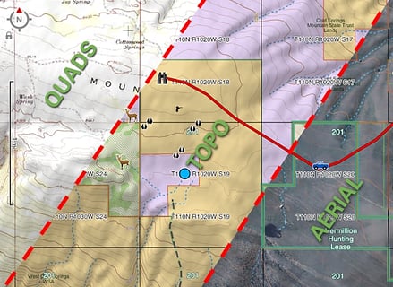
• Unlimited Topographic Maps, Quad Sheets and US NOAA Charts\\r
• Aerial Imagery\\r
• Hybrid Maps\\r
• Waypoints and Route Navigation\\r
• Tracking and Location Sharing\\r
• High-detail GPS Trip Logging\\r
• Unlimited Cloud Storage of Routes, Waypoints and Tracks\\r
• Online Trip Planning \\r
With the Hunt Edition subscription, sold separately, you get all of the Earthmate features, plus:\\r
• Game Management Units\\r
• Parcel Data (Provided where available)\\r
• Plan your hunts using waypoints, routes, aerial imagery, and the ability to import GPX files. All online planning automatically syncs to your Earthmate app through the cloud. When used in conjunction with an inReach, updates are then synced through Bluetooth to your active inReach device. \\r
Complete GPS navigation solution that works as a fully functional standalone app or paired with an inReach satellite communicator for the added power of global satellite connectivity when outside of cell phone range. \\r
Perfect for any outdoor enthusiast: hiking, camping, hunting, mountain biking, trail running, snowmobiling, off-roading, sailing, boating, bird watching, climbing, trail riding, and more! \\r
Unlimited map downloads – cache on your device and store for offline use, including:\\r
• North America topographic maps with 370,000 miles of trails, elevation and park data, public lands, and high-detail lake, river and stream data\\r
• USGS 24K Topo Quad Sheets\\r
• Detailed world base map\\r
• Aerial Imagery and Hybrid Maps\\r
• US NOAA charts\\r
• HUNT Edition – Game Management Units and Parcel Data for all 50 states \\r
Route Navigation and Waypoints\\r
• Create or view a route, navigate, drop waypoints\\r
• View useful trip statistics, such as elevation, time moving, max speed, bearing and distance \\r
Tracking and location sharing\\r
• Track your trip and send your location to family and friends with your own MapShare page when in cell phone range or when connected with an inReach satellite communicator \\r
High-detail GPS Trip Logging\\r
• Log a high-detail breadcrumb trail for reference later or to navigate back to the start. If connected to an inReach satellite communicator, your log is stored on the inReach. \\r
Online Trip Planning\\r
• Plan trips online ahead of time with our Explore portal\\r
• Sync routes and waypoints\\r
• Import GPX files \\r
Unlimited Cloud Storage and Syncing*\\r
• Waypoints and routes are synced to the cloud as you go\\r
• There’s no need for cables or SD cards\\r
• *When in cell phone range or connected to an inReach Explorer \\r
Pairs with inReach Satellite Communicators for Global Connectivity Regardless of Cell Coverage\\r
• The complete Earthmate for Outdoor is included with the purchase of an inReach Explorer device. Earthmate Hunt Edition is sold separately. \\r
• Control and access all the features of your inReach device from the app, including text messaging, SOS, tracking, and more. \\r
• Learn more about inReach at www.inreachdelorme.com \\r
获取手持 GPS 的所有功能,在你需要的一切计划一次旅行,浏览和分享您的户外探险成本的一小部分。狩猎地图数据现已通过的 Earthmate 亨特版。 \\r
•此应用程序需要使用配对德洛姆 inReach(访问因型号而异)或年度订阅室外或狩猎。 \\r
作为户外导航应用的最佳价值,的 Earthmate 是挤满了以下功能:\\r
•无限地形图,四表和美国 NOAA 图表\\r
•航拍图像\\r
•混合地图\\r
•航点和路线导航\\r
•跟踪和位置信息共享\\r
•高细节 GPS 旅行记录\\r
•途径,航点和轨迹无限云存储\\r
•在线旅行计划 \\r
随着亨特版订阅,单独出售,你会得到所有的 Earthmate 功能,再加上:\\r
•游戏经营单位\\r
•地块数据(提供如有)\\r
•使用航点,航线,航空影像,并导入 GPX 文件的能力规划您的狩猎。所有在线计划通过云计算自动同步到你的 Earthmate 应用程序。当与一个 inReach 使用,更新,然后通过蓝牙同步到您的积极 inReach 设备。 \\r
完整的 GPS 导航解决方案,作为一个全功能的独立的应用程序工作或与 inReach 卫星通信配对全球卫星连接的额外功率,当手机的范围之外。 \\r
适合任何户外运动爱好者:登山,露营,狩猎,山地自行车,越野跑,雪地摩托,越野,帆船,划船,观鸟,登山,骑马步道,以及更多! \\r
无限地图下载 - 您的设备和存储脱机使用,包括缓存:\\r
•北美地区的地形图与 370000 英里步道,海拔和公园数据,公共土地和高细节的湖泊,河流和流数据\\r
•USG...
《Earthmate》公司开发
InReach, LLC
《Earthmate》软件版本
2.7.100757