Handy GPS lite
- 安卓
- 2025-11-21
- ⏳ 已提交(07-31 09:58)
- 60 ℃
- 0 评论
摘要
 现实世界的远足 GPS(精简版)。无需注册。
Handy GPS (free)
BinaryEarth
备案号:待更新
 安卓
安卓《Handy GPS (free)》游戏 APP 是BinaryEarth开发的安卓系统应用软件,版本号:22.5,由丢塔游戏网整理,欢迎下载体验。
The perfect companion for your next outdoor adventure. Seek, find, record and return home with Handy GPS. \\r
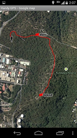
This app is a real navigation tool designed for outdoors sports like hiking, bushwalking, mountain biking, kayaking and trail riding. Its simple to use and works even in the remotest back country since it doesn\'t need network connectivity. It allows you to work in UTM or lat/lon coordinates so you can use it with your paper topographic maps. Waypoints and track logs recorded in the field can be be viewed later in Google Earth. \\r
NOTE: This is a free trial version and is limited to storing only 3 waypoints, and 20 track log points. You can use the trial version for as long as you want, but if you like this app, please install the paid version of \\\"Handy GPS\\\" to get an unlimited version with lots more features. Thanks! \\r
Base features:\\r
* Shows your current location in easting/northing (UTM) or in lat/lon.\\r
* Shows your speed, direction of travel, and total distance travelled in either metric or imperial/US units.\\r
* Can store your current location as a waypoint, and can store a track log to show where you\'ve been.\\r
* Waypoints and track logs can be imported from and exported to Google Earth KML and GPX files.\\r
* Allows manual entry of waypoints in UTM or lat/lon coords.\\r
* Can guide you to a waypoint with the \\\"Goto\\\" screen using true or compass bearings.\\r
* Optional audible proximity alarm on goto page.\\r
* Has a magnetic compass page (on devices with mag sensors only).\\r
* Computes the local magnetic declination at startup using the IGRF-12 model, for use on the goto page.\\r
* Can display either a simple map of your current location and the stored waypoints, or a Google Map if a data connection is available.\\r
* Supports the world-wide WGS84 datum along with the Australian datums and map grids AGD66, AGD84, GDA94, AGD, GDA, AMG, and MGA. (You can also use WGS84 for NAD83 maps).\\r
* Shows satellite locations and signal strengths graphically.\\r
* Can display simple or MGRS grid refs.\\r
* Waypoint-to-waypoint distance and direction.\\r
* Optional timer to record walk duration and compute average speed.\\r
* Has online help pages.\\r
* Now comes complete with an Android Wear version for use on your Android Wear smartwatch. (This has the same functionality as the HandyGPSWearFree app used to have. As before, the free Wear version is limited to storing only 1 waypoint).\\r
* Thoroughly tested by the developer on bushwalks. \\r
Extra features available only in the paid version:\\r
* Unlimited number of waypoints and track logs. (The free version is limited to 3 waypoints and 20 tracklog points)\\r
* A custom datum can be configured using ellipsoid and shift parameters.\\r
* Download offline map tiles for use in remote areas.\\r
* An email or SMS containing a clickable link showing your location can be sent to a friend.\\r
* An elevation profile of your route can be shown.\\r
* Can average GPS locations over time to give a more accurate result.\\r
* Show sun rise and set times.\\r
* Turn on/off flashlight from within app. \\r
Permissions required: (1) GPS - to determine your location, (2) Network access - for access to Google Map tiles, (3) SD card access - to load and store waypoints and tracklogs, (4) Camera access for taking pics (only available in full version), (5) Prevent phone from sleeping so that proximity alarm works, and (6) Modify system settings to allow the Wear version to dim the watch screen. \\r
Disclaimer: You use this app at your own risk. The developer accepts no responsibility for you getting lost as a result of using this app. Batteries in mobile devices can go flat. An alternate power source is recommended for extended hikes. \\r
Note that this app is also now available for iPhone and Windows Phone 8. Please see the respective app stores for details. \\r
完美的伴侣为你的下一个户外探险。寻找,发现,记录和使用 Handy GPS 回家。 \\r
这个程序是一个真正的导航工具专为户外运动,如远足,丛林徒步旅行,山地自行车,皮划艇和步道骑行。它使用简单,即使是在最偏远的背上的国家工作,因为它并不需要网络连接。它可以让你在 UTM 或纬度/经度坐标的工作,这样你就可以用你的论文的地形图使用它。记录在该领域的航点和轨迹日志可以在谷歌地球以后查看。 \\r
注意:
《Handy GPS (free)》公司开发
BinaryEarth
《Handy GPS (free)》软件版本
22.5